
By Emma Barhydt
Expect a mix of dry, sunny days and periods of rain this week, New Canaan, with temperatures consistently trending above average for mid-March. A system moving in over the weekend will bring gusty winds and widespread rain Sunday before clearing out by Monday afternoon. A dry and mild period follows midweek before another storm system brings rain back to the area by Thursday. Here’s what to expect day by day.
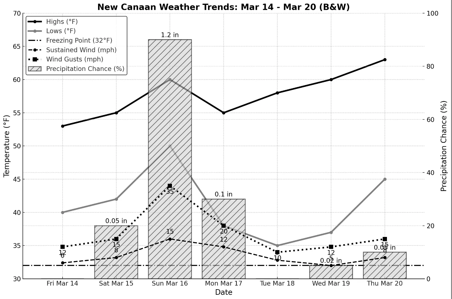
Friday, March 14 will be a partly sunny and dry day, with a high near 53°F. Winds remain light, making for a comfortable end to the workweek. Patchy fog may develop overnight as temperatures dip to 40°F, particularly in low-lying areas. No major travel impacts are expected, but early morning drivers on Saturday should be cautious of reduced visibility in fog-prone spots.
Saturday, March 15 kicks off the weekend with a milder but cloudier day, with highs in the mid-50s. The morning may start off with some patchy fog, but visibility improves by mid-morning as temperatures rise. Daytime hours remain mostly dry and calm, but by the evening, rain chances increase as a warm front approaches. Showers could develop after 8 PM, making for a damp Saturday night and the potential for wet roads for late-night travelers.
Sunday, March 16 brings gray skies, gusty winds, and periods of rain. Expect a high near 60°F, with increasing humidity ahead of an approaching cold front. Widespread rain, heavy at times, and gusty winds of 30+ mph are likely in the afternoon and evening. A thunderstorm is possible, and downpours may cause localized flooding in poor drainage areas, particularly after dark.
Monday, March 17’s morning commuters may encounter wet roads from the remnants of Sunday’s rain, but by mid-morning, conditions gradually improve. Skies turn partly sunny, with a high in the mid-50s as drier air moves in. A breezy northwest wind will help clear lingering clouds, making for a crisp but pleasant afternoon. The evening will be calm and cool, with lows in the upper 30s.
Tuesday, March 18 will be one of the nicest days of the week, with sunshine, light winds, and seasonably mild temperatures. Highs will reach the upper 50s, making for a comfortable and dry day. With no precipitation expected, roads will remain clear, providing excellent conditions for commuters and outdoor activities. Overnight lows will dip into the mid-30s, but no frost is expected.
Wednesday, March 19 is going to be a partly sunny and mild day, with highs near 60°F. A mix of sun and clouds will dominate, but a weak system passing to the north may bring increasing clouds by evening. Winds will remain light, ensuring a calm and comfortable day. With no major weather disruptions, it will be an excellent midweek break from the weekend’s wet conditions.
Thursday, March 20 is spring’s official arrival, and the weather will feel the part with highs in the low to mid-60s. Skies will feature a mix of sun and clouds, but an approaching storm system may bring increasing clouds late in the day. While Thursday should remain dry, a chance for showers returns overnight into Friday. The overall trend favors a warm start to spring, though wet weather may be on the horizon heading into the following weekend.
With the spring equinox arriving on March 20, New Canaan is shifting away from winter’s grip. Warmer temperatures and periodic rain events will likely continue through late March. While no sharp return to cold is expected, residents should stay prepared for spring showers and breezy conditions in the weeks ahead. Enjoy the warmer afternoons and keep an umbrella handy for the wet weekend ahead!