
By Emma Barhydt
As March settles in, New Canaan residents can expect a dynamic weather pattern, swinging from crisp, late-winter days to a taste of spring warmth before a cool and rainy close to the week. With temperatures gradually climbing and a midweek surge into the 60s, the forecast offers a mix of sunshine, breezes, and eventual showers.
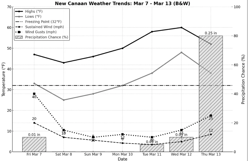
Friday, March 7 will bring plenty of sunshine but gusty winds. Highs will reach 47°F, but west winds at 15–25 mph, with gusts up to 40 mph, will make it feel much colder, especially in the morning. Drivers of high-profile vehicles should be cautious of crosswinds, especially on open roads. By evening, clouds increase, and temperatures dip to 33°F. A few sprinkles or flurries may pass through after midnight, but no accumulation is expected. Roads will remain dry.
On Saturday, March 8, a lighter breeze will make Saturday feel more comfortable despite a cool high of 43°F under mostly sunny skies. Travel conditions will be smooth, with no rain or snow expected. Saturday night will be notably cold, with lows dropping to the mid-20s. Expect patchy frost in the morning but no major travel concerns.
Sunday, March 9, continues the dry and calm pattern, with mostly sunny skies and a slightly warmer high of 46°F. Winds remain light, making for an ideal day for outdoor activities. Nighttime temperatures will dip to 28°F, with clear to partly cloudy skies. Roads remain dry, making for excellent travel conditions.
Monday, March 10 starts the transition to spring like temperatures, with highs reaching 50°F. Winds will be light, and travel conditions will remain ideal. The overnight low of 32°F keeps things seasonably cool, but warmer air continues to move in.
Tuesday, March 11 will be the first truly mild day, with sunny skies and highs climbing into the upper 50s. A gentle southwest breeze will make it feel even warmer. Morning commuters may still feel a slight chill with lows in the upper 30s, but by afternoon, lighter jackets will be enough. Travel impacts remain minimal, aside from potential sun glare on the roads.
Wednesday, March 12 will bring the warmest temperatures of the week, with highs near or above 60°F. Sunny and pleasant conditions will dominate, though clouds will increase by evening as a cold front approaches. Mild overnight temperatures in the upper 40s will keep things comfortable.
Thursday, March 13 will be cloudy and cooler, with highs in the low 50s. Showers are expected throughout the day, with rainfall totaling up to a quarter-inch. Roads may become slick during heavier showers, so allow extra travel time for the afternoon and evening commutes. Winds will shift westward and strengthen by evening, bringing gusts up to 25 mph as the front passes. Nighttime lows will dip to the upper 30s, with potential patchy icing on wet roads overnight.
With winter’s grip loosening, layers are still necessary, but lighter jackets will make an appearance by midweek. Whether you’re savoring a sunny afternoon walk or cozying up inside on a rainy Thursday, this week’s weather offers a little something for everyone. Forecasters are monitoring a potential storm system that may impact the region after March 13. If it tracks closer, stronger winds and heavier rain could develop late Thursday into Friday. Travelers with late-week plans should check for updates, as conditions could become more unsettled.