
By Emma Barhydt
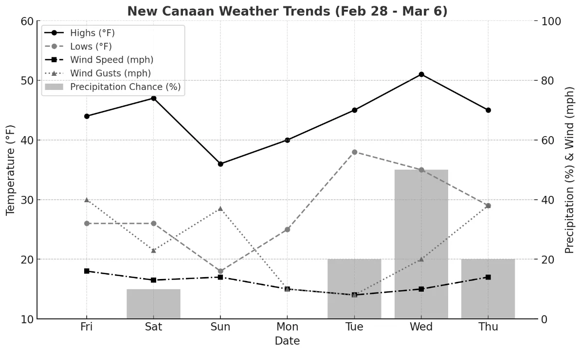
New Canaan can expect a week of fluctuating temperatures, breezy conditions, and occasional rain as March approaches. The week’s forecast shows mostly dry conditions, with light rain midweek and temperatures ranging from the upper teens overnight to low 50s during the day.
Friday, February 28: A breezy end to the workweek will feature a mix of sun and clouds with temperatures peaking at 44°F. Strong west-northwest winds at 16 mph, gusting up to 40 mph, will make the air feel cooler, so layers are recommended for outdoor activities. As evening falls, temperatures will drop to 26°F with mostly cloudy skies and lighter southern winds at 7 mph. The chance of rain remains low, ensuring dry conditions heading into the weekend.
Saturday, March 1: Clouds will dominate the sky throughout Saturday, with temperatures warming slightly to 47°F. Winds from the west-southwest will reach 13 mph, with gusts up to 23 mph, adding a brisk feel to the day. While there’s a small chance of light showers, any rainfall will be minimal. The evening will clear up, with temperatures dipping to 26°F under mostly clear skies. Winds will shift to the west-northwest, maintaining gusts near 30 mph, keeping the night crisp.
Sunday, March 2: Sunday will deliver the coldest daytime temperatures of the week, with a high of just 36°F. Despite mostly sunny skies, strong morning breezes from the northwest at 14 mph—gusting up to 37 mph—will keep the air sharp. The evening brings clear skies and a steep temperature drop to 18°F. Winds will ease slightly but remain noticeable at 10 mph, with gusts up to 2 mph.
Monday, March 3: Sunshine returns on Monday, bringing calm and dry conditions. Temperatures will climb into the low 40s, accompanied by light northwest winds, making it a pleasant day for outdoor errands. The night will stay mostly clear, with temperatures falling to the mid 20s and light northeast winds. No precipitation is expected, providing a stable start to the week.
Tuesday, March 4: A shift in weather arrives Tuesday, with mostly cloudy skies and milder temperatures in the mid 40s. Winds will remain light, allowing for a comfortable day despite the cloud cover. Overnight, temperatures will fall to the upper 30s as overcast conditions persist. Light rain is expected but will be minimal, with no significant impact on travel or evening plans.
Wednesday, March 5: The mildest day of the week, Wednesday will see temperatures rise into the low 50s, though skies will remain mostly cloudy. Light rain is expected for a few hours during the day, accompanied by steady winds at 10 mph and stronger gusts. Overnight, rain will become steadier, with temperatures dropping to the mid 30s. Winds will increase to 14 mph, and about half an inch of rainfall is expected, making it the wettest period of the week.
Thursday, March 6: The week concludes with a return to cooler, breezy conditions. Thursday will be mostly cloudy, with a high in the mid 40’s and a chance of a light morning shower. Winds will pick up throughout the day, with gusts reaching up to 35 mph. Nightfall may bring brief periods of snow, and temperatures will drop to the high 20’s. Strong winds will persist into the evening, with gusts up to 38 mph, providing a brisk end to the week.
As New Canaan transitions into spring, the weather remains a familiar mix of brisk breezes, cool evenings, and the occasional light rain. It’s the kind of week that calls for warm layers, friendly conversations over coffee, and maybe a good book by the fire.