
By Emma Barhydt
New Canaan, brace yourself for a rollercoaster of winter weather in the coming days. From a wintry mix and chilly breezes to a brief warm-up before an arctic blast returns, the forecast promises plenty of variety. Here’s what to expect as February’s unpredictable mood swings continue.
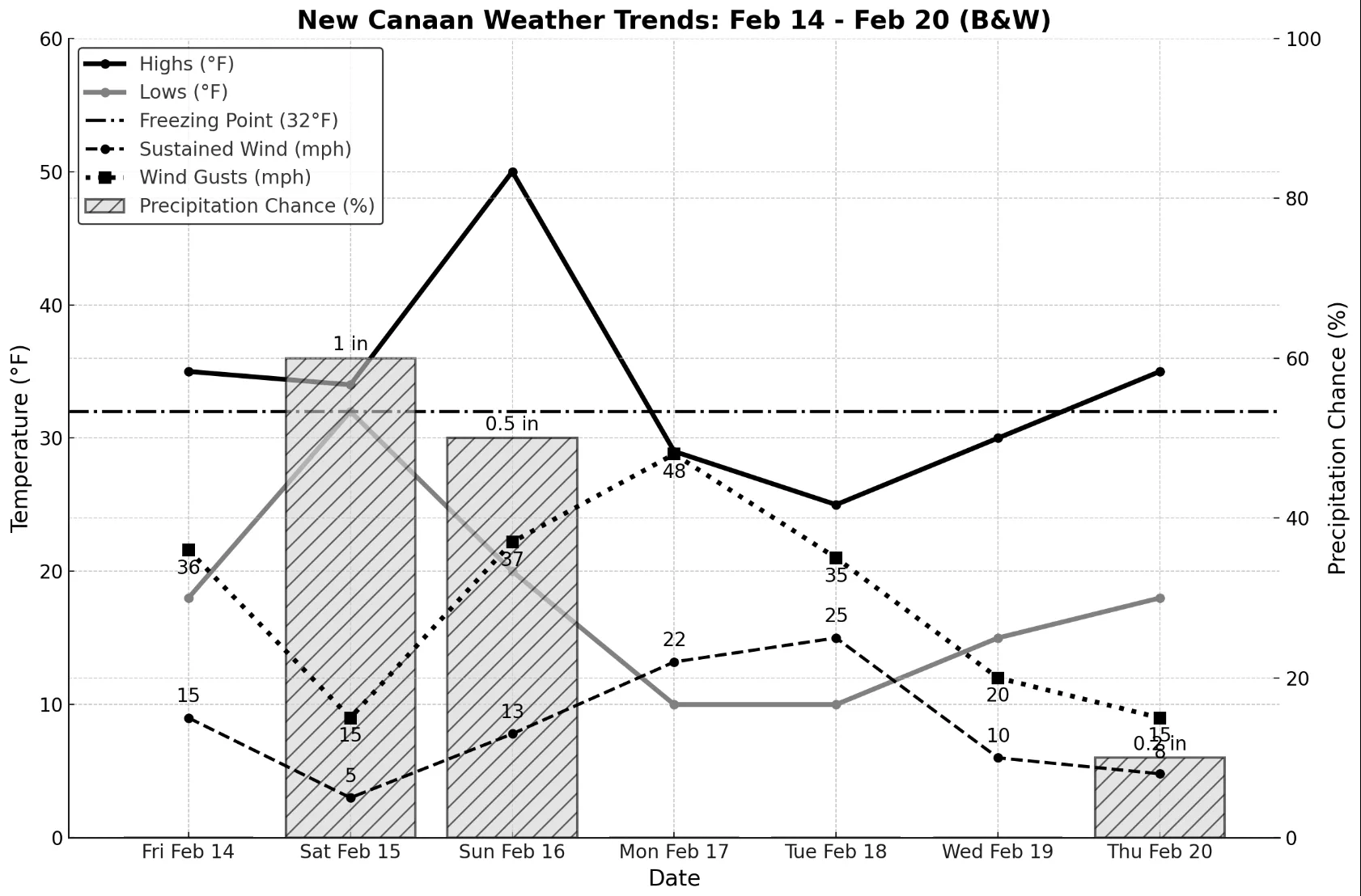
Friday, February 14: Expect a chilly day with a high of 35°F, though it will feel even colder thanks to gusty northwest winds reaching up to 36 mph. The sun will be out, but with only 15% cloud cover, there won’t be much to block the breeze. There is no precipitation expected. By night, temperatures will dip to 18°F under thick cloud cover. Winds will calm a bit, coming from the west at 7 mph with occasional gusts up to 20 mph. It’ll stay dry, but the overcast sky will make for a gloomy evening.
Saturday, February 15: Bundle up, New Canaan! A chilly 34°F high will be accompanied by overcast skies, setting the stage for a wintry mix in the afternoon. Expect light snow and rain by midday, with up to an inch of accumulation. Winds will be mild from the southeast at 5 mph, gusting up to 15 mph. As night falls, temperatures will hover around 32°F but feel more like 25°F with the breeze. Rain will persist, making for a damp evening.
Sunday, February 16: A dramatic warm-up is on the way, with temperatures spiking to 50°F. Morning rain showers will linger into early afternoon, so expect some slick roads and sidewalks. Winds will pick up from the southeast at 13 mph, gusting to 37 mph. By evening, temperatures will plummet to 20°F, with a slight chance of lingering showers. Winds will shift westward and strengthen overnight.
Monday, February 17: After Sunday’s warmth, winter returns in full force. Expect a high of just 29°F, but it will feel much colder with powerful 22 mph winds and gusting up to 48 mph. A mix of sunshine and clouds will brighten the day. The UV index will be moderate, so if you’re braving the outdoors, layer up and protect your skin. By night, temperatures will plummet to 10°F, with wind chills as low as -9°F. Clear skies will dominate, but the bitter cold will make for a frosty night across town.
Tuesday, February 18: Another crisp and windy day ahead! Temperatures will hover in the mid-20s, but strong westerly winds—gusting up to 35 mph—will make it feel significantly colder. The sky will be clear, offering plenty of winter sunshine. Nighttime temperatures will plunge to around 10°F, with wind chills well below zero. The gusty northwest winds won’t let up, making for a freezing but clear night over New Canaan.
Wednesday, February 19: Expect similar frigid conditions, with highs reaching the low 30s. A moderate west-northwest wind will keep things brisk, making it feel even colder. Skies will remain mostly clear, offering bright but chilly conditions. By nighttime, temperatures will dip into the mid-teens, with occasional gusts. Clouds will gradually increase, but no precipitation is expected.
Thursday, February 20: A slight warm-up is in store, with daytime highs reaching the mid 30s. The west-northwest breeze will be lighter, making it a bit more bearable for those venturing outside. Skies will be mostly sunny today. As night falls, temperatures will drop to the high teens, and increasing cloud cover may hint at some precipitation in the days ahead.
Stay bundled up and keep an eye on shifting conditions as we navigate the season’s final stretch.