
By Emma Barhydt
Local Weather: Prep for Frigid Temps in The Week Ahead
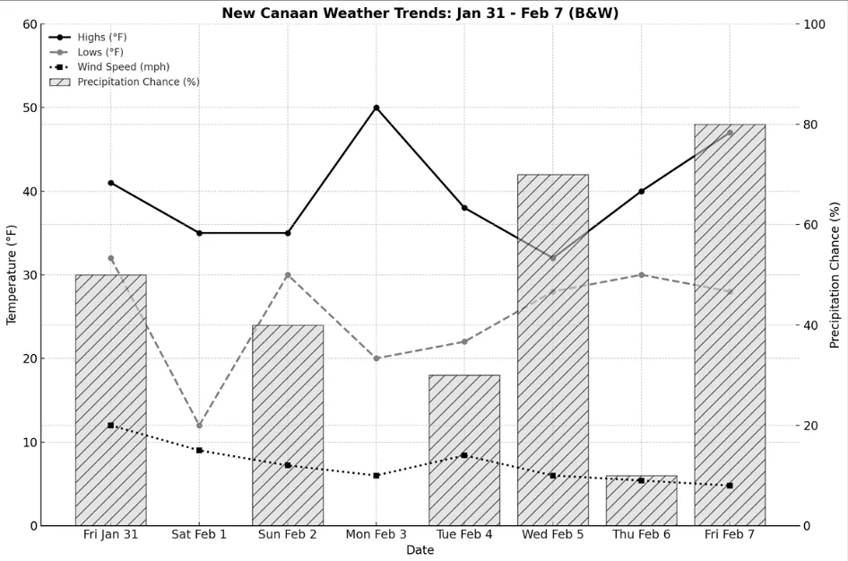
New Canaan is closing out January with a mix of rain, snow, and winter sunshine as the first week of February brings shifting temperatures and varied conditions. From mild days to brisk nights, residents can expect everything from flurries to a brief early week warm-up before winter makes another return.
Friday, January 31, will bring partly sunny skies with a high of 41°F and a low of 32°F. We’ll receive about a half inch of rain today which will continue into the evening. In the evening wind gusts will be as high as 35 mph.
Saturday, February 1, kicks off the new month with a bright but brisk morning. Highs will reach the mid-30s, and the day will be partly sunny with some early breezes. Evening lows will drop into the low teens under partly cloudy skies.
Sunday, February 2, welcomes seasonal flurries, with highs in the mid 30s. Snow showers will continue into the evening, with lows settling in the low 30s. Expect a light dusting of less than an inch by morning.
Monday, February 3, sees a warming trend, with highs soaring to the low 50s before dipping back into the low 20s overnight. Skies will be partly cloudy throughout the day and evening.
Tuesday, February 4, stays mild, with highs in the upper 30s and a mix of sun and clouds. By evening, temperatures will fall into the low 20s, bringing a mix of snow and ice, though accumulation will stay under half an inch.
Wednesday, February 5, starts with lingering snow, adding just over an inch before tapering off in the afternoon. Highs will hover in the low 30s, with evening lows in the upper 20s. Clouds will gradually clear overnight.
Thursday, February 6, brings a welcome break in the winter weather, with sunny skies, highs in the low 40s, and only a few passing clouds. The evening will see increasing cloud cover, with lows in the low-30s and calming winds.
Friday, February 7, turns overcast with the chance for light morning snow, shifting to a mix of rain and snow in the afternoon. Highs will reach the upper-40s, while evening temperatures drop into the upper 20s, allowing any rain to turn back into snow. Expect up to two inches of accumulation.
February is off to a dynamic start, but winter isn’t done yet—so keep the layers handy and stay ready for whatever the season has in store.
Nationally: The Week Ahead
Northeast: The Northeast will experience a mix of winter conditions during this period. Friday, January 31, brings milder temperatures with periods of rain. The weekend sees a return to colder conditions, with breezy and partly sunny skies on Saturday, February 1, and a chance of light snow on Sunday, February 2. Early in the week, temperatures will be milder with variable cloudiness, but expect a drop in temperatures midweek, accompanied by intervals of clouds and sunshine. Snow is anticipated on Wednesday, February 5, followed by mostly sunny skies on Thursday, February 6. The week concludes with cloudy conditions and a mix of morning flurries and afternoon rain on Friday, February 7. Overall, while winter’s chill persists, there will be periods of milder weather and sunshine to enjoy.
Southeast: The Southeast is set to experience mild and pleasant conditions throughout the week. Friday, January 31, may bring periods of rain and a thunderstorm, but this will give way to plenty of sunshine and mild temperatures over the weekend. The warmth continues into the week, with temperatures well above average for the region reaching the low 70s with ample sunshine. Cloud cover increases slightly midweek, leading to potential showers by Friday, February 7. This period offers an excellent opportunity for outdoor activities, with comfortable temperatures and mostly clear skies.
Midwest: The Midwest will experience typical winter variability. Friday, January 31, starts with windy conditions and a mix of rain and snow, though little accumulation is expected. The weekend brings cloudy skies, with milder temperatures on Sunday, February 2. A cooling trend begins on Monday, February 3, with mostly cloudy conditions, leading to colder temperatures and partial sunshine by Tuesday, February 4. The week continues with considerable cloudiness and occasional sunshine, providing a balance between winter’s chill and moments of brightness.
Southwest: The Southwest will enjoy a stretch of pleasant weather. Friday, January 31, is expected to be mostly sunny and less humid, setting the tone for the weekend. Saturday and Sunday offer plenty of sunshine and warm, above-average temperatures, reaching the mid-70s. The warmth persists into the week, with mostly sunny to partly sunny skies. Cloud cover increases slightly midweek, bringing chances of showers by Wednesday, February 5, and Thursday, February 6. The week concludes with morning clouds giving way to afternoon sunshine on Friday, February 7. This period provides ample opportunities to enjoy outdoor activities under favorable conditions.
Northwest: The Northwest will experience a mix of rain and snow showers during this period. Friday, January 31, brings breezy conditions with periods of rain. The weekend remains chilly with temps slightly below average and sun and clouds accompanied by passing showers, and the possibility of wet snowflakes mixed in. Early in the week, expect intervals of clouds and sun with occasional rain or snow showers. Midweek brings partial sunshine, but the chill persists. The week concludes with considerable cloudiness and periods of ice changing to rain on Friday, February 7. While the chill remains, there will be moments of brightness to look forward to.
West Coast: The West Coast is set to enjoy mild and stable weather throughout the week. Friday, January 31, offers times of clouds and sun, with temperatures around 68°F (20°C). The weekend brings sun through high clouds, with temperatures reaching the low 70s°F (around 22°C). The pleasant conditions continue into the week, with mostly sunny to partly sunny skies. Midweek sees an increase in low clouds, but these are expected to clear, leading to a brightening sky by Thursday, February 6. The week concludes with sun through high clouds on Friday, February 7. This period provides a great opportunity to enjoy outdoor activities under favorable conditions.
Please note that weather conditions can change, and it’s advisable to check the latest forecasts from reliable sources such as the National Weather Service and AccuWeather for the most up-to-date information.